
Thank you for supporting this site ❤️
Make a donation
Make a donation
Grande Island topographic map
Click on the map to display elevation.
Thank you for supporting this site ❤️
Make a donation
Make a donation
About this map
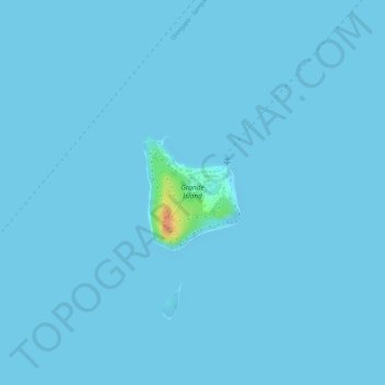
Name: Grande Island topographic map, elevation, terrain.
Location: Grande Island, Bataan, Central Luzon, Philippines (14.76776 120.22319 14.77581 120.23033)
Average elevation: 1 m
Minimum elevation: 0 m
Maximum elevation: 43 m
Thank you for supporting this site ❤️
Make a donation
Make a donation
Other topographic maps
Click on a map to view its topography, its elevation and its terrain.