
منطقة النبك topographic map
Interactive map
Click on the map to display elevation.
About this map
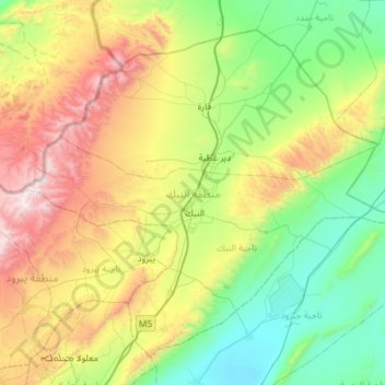
Name: منطقة النبك topographic map, elevation, terrain.
Location: منطقة النبك, Gouvernorat de Rif Dimachq, Syrie (33.84513 36.47861 34.24892 37.05233)
Average elevation: 1,359 m
Minimum elevation: 783 m
Maximum elevation: 2,611 m
Other topographic maps
Click on a map to view its topography, its elevation and its terrain.
جبل الشيخ
Syrie > Gouvernorat de Rif Dimachq
Le mont Hermon (appelé en hébreu : הר חרמון, Har Hermon ; et en arabe : جبل الشيخ, Jabal ash-Shaykh, soit « montagne du cheikh » ou « mont enneigé » ou Haramoun) est une montagne de l'Anti-Liban, culminant à 2 814 mètres d'altitude.
Average elevation: 2,516 m