
Eisenach topographic map
Interactive map
Click on the map to display elevation.
About this map
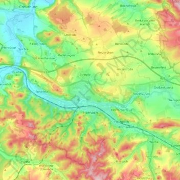
Name: Eisenach topographic map, elevation, terrain.
Location: Eisenach, Wartburgkreis, Thüringen, 99817, Duitsland (50.93081 10.17524 51.05239 10.39152)
Average elevation: 298 m
Minimum elevation: 190 m
Maximum elevation: 468 m
Other topographic maps
Click on a map to view its topography, its elevation and its terrain.
Hörschel
Duitsland > Thüringen > Wartburgkreis > Eisenach
Hörschel, Eisenach, Wartburgkreis, Thüringen, 99819, Duitsland
Average elevation: 254 m
Creuzburg
Duitsland > Thüringen > Wartburgkreis
Creuzburg, Amt Creuzburg, Hainich-Werratal, Wartburgkreis, Thüringen, Duitsland
Average elevation: 295 m
Heldrastein
Duitsland > Thüringen > Wartburgkreis > Treffurt
Heldrastein, Treffurt, Wartburgkreis, Thüringen, 99830, Duitsland
Average elevation: 352 m