
Nandi Hills topographic map
Interactive map
Click on the map to display elevation.
About this map
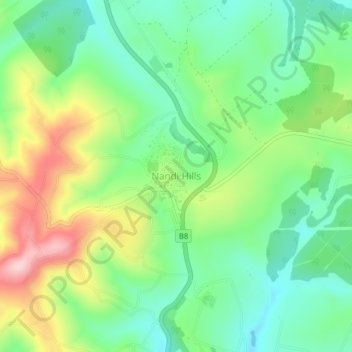
Name: Nandi Hills topographic map, elevation, terrain.
Location: Nandi Hills, Nandi County, Kenya (0.08633 35.16559 0.12633 35.20559)
Average elevation: 2,028 m
Minimum elevation: 1,940 m
Maximum elevation: 2,184 m
Nandi Hills is located in a highland area of lush green rolling hills at the edge of the Great Rift Valley in the southwestern part of Kenya. It is located approximately 303 kilometres (188 mi), by road, northwest of Nairobi, the capital and largest city in the country. The coordinates of Nandi Hills, Kenya are:0°06'01.0"N, 35°10'35.0"E (Latitude:0.100278; Longitude:35.176389). Nandi Hills lies an elevation of approximately 2,047 metres (6,716 ft), above sea level.
Other topographic maps
Click on a map to view its topography, its elevation and its terrain.
Nandi Hills
Nandi Hills, Nandi County, Rift Valley, Kenya
Average elevation: 1,983 m