
Make a donation
Chiang Rai Province topographic map
Click on the map to display elevation.
Make a donation
Chiang Rai Province
The average elevation of the province is 580 metres (1,903 ft). The north of the province is part of the so-called Golden Triangle, where the borders of Thailand, Laos and Burma converge, an area which prior to the rise of agricultural production of coffee, pineapple, coconuts, and banana plantations, was unsafe because of drug smuggling across the borders. The Mekong River forms the boundary with Laos, the Mae Sai and Ruak River with Burma. Through the town of Chiang Rai itself, flows the "Mae Kok" Kok River and south of it the Lao River, a tributary of the Kok.
Make a donation
About this map
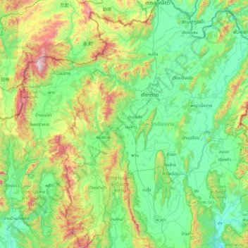
Name: Chiang Rai Province topographic map, elevation, terrain.
Location: Chiang Rai Province, Thailand (18.99990 99.25799 20.46481 100.57850)
Average elevation: 644 m
Minimum elevation: 272 m
Maximum elevation: 2,241 m
Make a donation
Other topographic maps
Click on a map to view its topography, its elevation and its terrain.
Make a donation
Make a donation
Make a donation
Make a donation
Make a donation
Make a donation
Make a donation
Make a donation
Mae Haad Cove (Nudist Beach)
Thailand > Ko Pha-ngan District > Baan Wang Ta Kien > Haad Mae Haad
Average elevation: 42 m
Make a donation
Make a donation
Phu Kradung
Thailand > Phu Kradueng District
Phu Kradueng National Park (Thai: อุทยานแห่งชาติภูกระดึง), in the Si Than sub-district of Amphoe Phu Kradueng, Loei Province, is a national park in Thailand. It has a high point of 1,316 m (4318 ft) elevation at Khok Moei. It was proclaimed a national park on 23…
Average elevation: 1,183 m
Make a donation
Make a donation
Make a donation
Make a donation
Make a donation
Make a donation
Ban Khlong Ban Mai
Thailand > Mueang Pathum Thani District > Ban Mai Subdistrict
Average elevation: 4 m
Make a donation
Make a donation
Make a donation
Make a donation
Make a donation
Make a donation
Mae Salong
Thailand > Mae Fa Luang > Mae Fa Luang district
Mae Salong is a hilltop village in the Mae Fa Luang district of Thailand's Chiang Rai Province, about 80 kilometres (50 mi) from Chiang Rai. Mae Salong is on the highest peak of the Doi Mae Salong range of mountains, at an elevation of 1,134 metres (3,722 ft) above sea level. It has an alpine-like climate,…
Average elevation: 1,035 m
Make a donation
Make a donation