
Easthampton topographic map
Interactive map
Click on the map to display elevation.
About this map
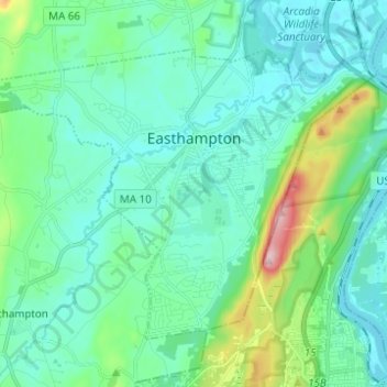
Name: Easthampton topographic map, elevation, terrain.
Location: Easthampton, Hampshire County, Massachusetts, United States (42.22325 -72.73673 42.29189 -72.61318)
Average elevation: 85 m
Minimum elevation: 25 m
Maximum elevation: 355 m
The Mount Tom State Reservation extends into the eastern part the city, and many local residents hike up to enjoy the view of the Pioneer Valley from the rock ledges. Mount Tom, with a summit elevation of 1,202 feet (366 m), is the highest traprock peak on the Metacomet Ridge, a linear mountain range that extends from Long Island Sound to the Vermont border. Mount Tom is characterized by its high cliffs, sweeping vistas, and microclimate ecosystems. The 110-mile (180 km) Metacomet-Monadnock Trail traverses the mountain.
Other topographic maps
Click on a map to view its topography, its elevation and its terrain.
Northampton
United States > Massachusetts > Hampshire County
Northampton, Hampshire County, Massachusetts, United States
Average elevation: 71 m
Amherst
United States > Massachusetts > Hampshire County
Amherst, Hampshire County, Massachusetts, United States
Average elevation: 120 m
Swift River
United States > Massachusetts > Hampshire County > Belchertown
Swift River, Belchertown, Hampshire County, Massachusetts, United States
Average elevation: 160 m
Chesterfield
United States > Massachusetts > Hampshire County
Chesterfield, Hampshire County, Massachusetts, United States
Average elevation: 364 m
Huntington
United States > Massachusetts > Hampshire County
Huntington, Hampshire County, Massachusetts, United States
Average elevation: 311 m
Southampton
United States > Massachusetts > Hampshire County
Southampton, Hampshire County, Massachusetts, United States
Average elevation: 131 m
South Amherst
United States > Massachusetts > Hampshire County > Amherst
South Amherst, Amherst, Hampshire County, Massachusetts, 01004, United States
Average elevation: 60 m
Mount Tom
United States > Massachusetts > Hampshire County > Easthampton
Mount Tom, Easthampton, Hampshire County, Massachusetts, 01061, United States
Average elevation: 69 m
Leeds
United States > Massachusetts > Hampshire County > Northampton
Leeds, Northampton, Hampshire County, Massachusetts, 01053, United States
Average elevation: 133 m
Hadley
United States > Massachusetts > Hampshire County
Hadley, Hampshire County, Massachusetts, 01035, United States
Average elevation: 73 m
Belchertown
United States > Massachusetts > Hampshire County
Belchertown, Hampshire County, Massachusetts, 01007, United States
Average elevation: 150 m
Fort River
United States > Massachusetts > Hampshire County > Amherst
Fort River, Amherst, Hampshire County, Massachusetts, United States
Average elevation: 59 m
South Hadley
United States > Massachusetts > Hampshire County
South Hadley, Hampshire County, Massachusetts, 01075, United States
Average elevation: 84 m
Goss Heights
United States > Massachusetts > Hampshire County > Huntington
Goss Heights, Huntington, Hampshire County, Massachusetts, 01050, United States
Average elevation: 229 m
Florence
United States > Massachusetts > Hampshire County > Northampton
Florence, Northampton, Hampshire County, Massachusetts, 01062, United States
Average elevation: 78 m
Cummington
United States > Massachusetts > Hampshire County
Cummington, Hampshire County, Massachusetts, 01026, United States
Average elevation: 435 m
Westhampton
United States > Massachusetts > Hampshire County
Westhampton, Hampshire County, Massachusetts, United States
Average elevation: 260 m
Plainfield
United States > Massachusetts > Hampshire County
Plainfield, Hampshire County, Massachusetts, 01070, United States
Average elevation: 484 m
Pelham
United States > Massachusetts > Hampshire County
Pelham, Hampshire County, Massachusetts, United States
Average elevation: 245 m
Ware
United States > Massachusetts > Hampshire County
Ware, Hampshire County, Massachusetts, 01082, United States
Average elevation: 198 m
Hatfield
United States > Massachusetts > Hampshire County
Hatfield, Hampshire County, Massachusetts, United States
Average elevation: 62 m
Worthington
United States > Massachusetts > Hampshire County
Worthington, Hampshire County, Massachusetts, United States
Average elevation: 411 m
West Pelham
United States > Massachusetts > Hampshire County > Pelham > West Pelham
West Pelham, Pelham, Hampshire County, Massachusetts, 01002, United States
Average elevation: 142 m
North Amherst
United States > Massachusetts > Hampshire County > Amherst
North Amherst, Amherst, Hampshire County, Massachusetts, 01003, United States
Average elevation: 67 m
Brown Ellison Park
United States > Massachusetts > Hampshire County > Granby
Brown Ellison Park, Granby, Hampshire County, Massachusetts, United States
Average elevation: 86 m
Middlefield
United States > Massachusetts > Hampshire County
Middlefield, Hampshire County, Massachusetts, 01243, United States
Average elevation: 443 m
North Hadley
United States > Massachusetts > Hampshire County > Hadley
North Hadley, Hadley, Hampshire County, Massachusetts, 01038, United States
Average elevation: 48 m
Amherst Woods
United States > Massachusetts > Hampshire County > Amherst > Amherst Woods
Amherst Woods, Amherst, Hampshire County, Massachusetts, 01004, United States
Average elevation: 84 m
Granby
United States > Massachusetts > Hampshire County
Granby, Hampshire County, Massachusetts, 01033, United States
Average elevation: 109 m
Williamsburg
United States > Massachusetts > Hampshire County
Williamsburg, Hampshire County, Massachusetts, United States
Average elevation: 280 m
Mount Holyoke
United States > Massachusetts > Hampshire County > Hadley
Mount Holyoke, Hadley, Hampshire County, Massachusetts, 01060, United States
Average elevation: 105 m