
Fort River topographic map
Interactive map
Click on the map to display elevation.
About this map
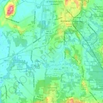
Name: Fort River topographic map, elevation, terrain.
Average elevation: 59 m
Minimum elevation: 31 m
Maximum elevation: 158 m
Other topographic maps
Click on a map to view its topography, its elevation and its terrain.
South Amherst
United States > Massachusetts > Hampshire County > Amherst
South Amherst, Amherst, Hampshire County, Massachusetts, 01004, United States
Average elevation: 60 m
North Amherst
United States > Massachusetts > Hampshire County > Amherst
North Amherst, Amherst, Hampshire County, Massachusetts, 01003, United States
Average elevation: 67 m
Amherst Woods
United States > Massachusetts > Hampshire County > Amherst > Amherst Woods
Amherst Woods, Amherst, Hampshire County, Massachusetts, 01004, United States
Average elevation: 84 m