
Make a donation
Erzurum topographic map
Click on the map to display elevation.
Make a donation
Erzurum
The surface area of the province of Erzurum is the fourth biggest in Turkey. The majority of the province is elevated. Most plateaus are about 2,000 m (6,600 ft) above sea level, and the mountainous regions beyond the plateaus are 3,000 m (9,800 ft) and higher. Depression plains are located between the mountains and plateaus. The southern mountain ranges include the Palandöken Mountains (highest peak Büyük Ejder 3,176 m or 10,420 ft high) and the Şahveled Mountains (highest peak Çakmak Mountain 3,063 m or 10,049 ft high). The northern mountain ranges are the second row elevations of the North Anatolian Mountains, i.e. Mescit Mountains (highest peak 3,239 m or 10,627 ft high), Kargapazarı Mountains (highest peak 3,169 m or 10,397 ft high) and Allahuekber Mountains. The two depression plains between these mountainous areas are Erzurum Plains and Hasankale Plains. Aras Mountains starts first in Erzurum. Then it extends towards the borders of Ağrı and Kars. Erzurum province is surrounded by Bingöl and Akdoğan Mountains from the south.
Make a donation
About this map
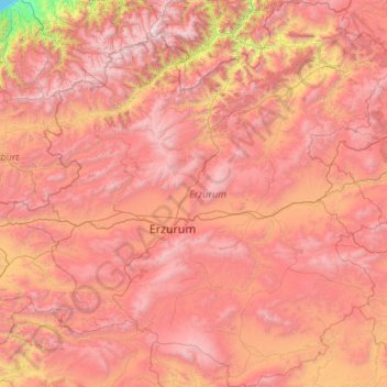
Name: Erzurum topographic map, elevation, terrain.
Location: Erzurum, Eastern Anatolia Region, Turkey (39.15210 40.24604 40.97600 42.62019)
Average elevation: 2,008 m
Minimum elevation: 0 m
Maximum elevation: 3,908 m
Make a donation
Other topographic maps
Click on a map to view its topography, its elevation and its terrain.
Make a donation
Make a donation
Make a donation
Make a donation
Make a donation
Make a donation
Make a donation
Tokat
Turkey > Tokat > Tokat Merkez
Tokat has a hot-summer Mediterranean climate, or alternatively a continental climate (Köppen: Csa, Trewartha: Dc). Due to the relatively high altitude and inland location, winters are fairly cold with average lows below the freezing point and significant snowfall.
Average elevation: 1,137 m
Make a donation
Make a donation
Mount Erciyes
The climate of the region is influenced by topography, with the Taurus and Kaçkar Mountains blocking the entry of moisture into Anatolia. Summers are dry and hot and winters wet and cold; in Kayseri, summer temperatures are about 19 °C (66 °F) and winter temperature about 0 °C (32 °F). Precipitation at…
Average elevation: 3,329 m
Make a donation
Eskisehir
Eskişehir has a cold semi-arid climate (BSk) under the Köppen climate classification, and a temperate continental climate (Dc) under the Trewartha climate classification. The city features cold, snowy winters and warm, dry summers. Rainfall occurs mostly during the spring and autumn. Due to Eskişehir's high…
Average elevation: 949 m
Make a donation
Make a donation
Make a donation
Make a donation
Make a donation
Denizli
Denizli is an industrial city in the southwestern part of Turkey and the eastern end of the alluvial valley formed by the river Büyük Menderes, where the plain reaches an elevation of about three hundred and fifty metres (1,148 ft). Denizli is located in the country's Aegean Region.
Average elevation: 740 m
Make a donation
Make a donation
Make a donation
Make a donation
Make a donation