
San Antonio topographic map
Interactive map
Click on the map to display elevation.
About this map
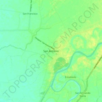
Name: San Antonio topographic map, elevation, terrain.
Location: San Antonio, Nueva Ecija, Central Luzon, 3108, Philippines (15.26671 120.81001 15.34671 120.89001)
Average elevation: 15 m
Minimum elevation: 7 m
Maximum elevation: 23 m
Other topographic maps
Click on a map to view its topography, its elevation and its terrain.
Talavera
Talavera is relatively flat, with a slope ranging from 0 to 3%. Its elevation, which ranges from 31m to 61m above sea level, with an average elevation of 42m, is importantly suitable for agricultural, commercial and industrial developments. Its aggregate arable land amounts to 12, 6981 ha or 89.075% of its…
Average elevation: 49 m