
Make a donation
Talavera topographic map
Click on the map to display elevation.
Make a donation
Talavera
Talavera is relatively flat, with a slope ranging from 0 to 3%. Its elevation, which ranges from 31m to 61m above sea level, with an average elevation of 42m, is importantly suitable for agricultural, commercial and industrial developments. Its aggregate arable land amounts to 12, 6981 ha or 89.075% of its total land area, of which less than 70% is irrigated or cultivated. Its land form consists generally of a broad expanse of low-lying level plains, with flattened terrains covered usually with greens or grasslands. The land profile is completely leveled, with relatively smooth-rolling surface and with little or no change at all in elevation.
Make a donation
About this map
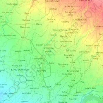
Name: Talavera topographic map, elevation, terrain.
Location: Talavera, Nueva Ecija, Central Luzon, 3114, Philippines (15.52730 120.87036 15.70895 120.99225)
Average elevation: 49 m
Minimum elevation: 25 m
Maximum elevation: 88 m
Make a donation
Other topographic maps
Click on a map to view its topography, its elevation and its terrain.