
Mosteiros topographic map
Interactive map
Click on the map to display elevation.
About this map
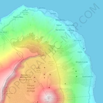
Name: Mosteiros topographic map, elevation, terrain.
Location: Mosteiros, 8110, Cape Verde (14.94831 -24.40286 15.05196 -24.28646)
Average elevation: 846 m
Minimum elevation: 0 m
Maximum elevation: 2,802 m
Other topographic maps
Click on a map to view its topography, its elevation and its terrain.
São Vicente
The island is roughly rectangular in shape with an area of 226.7 square kilometres (87.5 square miles). From east to west it measures 24.3 kilometres (15.1 miles) and from north to south 16.3 kilometres (10.1 miles). The island, of volcanic origin, is fairly flat. The last volcanic activity is considered to…
Average elevation: 46 m
Espargos
Cape Verde > Sal > Espargos
The highest point of Espargos is Monte Curral, elevation 109 meters, where the radar station and the control tower for the airport are located. The Amílcar Cabral International Airport is situated directly southwest of the city centre. The head offices of Cabo Verde Express are located at the airport. The…
Average elevation: 34 m