
São Vicente topographic map
Interactive map
Click on the map to display elevation.
About this map
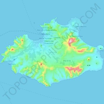
Name: São Vicente topographic map, elevation, terrain.
Location: São Vicente, Cape Verde (16.77660 -25.08599 16.92235 -24.85869)
Average elevation: 46 m
Minimum elevation: -2 m
Maximum elevation: 716 m
The island is roughly rectangular in shape with an area of 226.7 square kilometres (87.5 square miles). From east to west it measures 24.3 kilometres (15.1 miles) and from north to south 16.3 kilometres (10.1 miles). The island, of volcanic origin, is fairly flat. The last volcanic activity is considered to have taken place in the Pleistocene. Although very eroded, some craters still remain, for instance Viana. Its highest point is Monte Verde, located in the eastern part with an altitude of 744 metres (2,441 feet). Other mountains include Madeiral (680 m), Caixa (535 m) and Monte Cara (490 m).
Other topographic maps
Click on a map to view its topography, its elevation and its terrain.
Mindelo
Cape Verde > São Vicente > Mindelo
Mindelo, São Vicente, 2110, Cape Verde
Average elevation: 30 m