
Dushanbe topographic map
Interactive map
Click on the map to display elevation.
Dushanbe
Dushanbe (Tajik: Душанбе, IPA: ; meaning Monday in Persian) is the capital and largest city of Tajikistan. As of January 2020, Dushanbe had a population of 863,400. Until 1929, the city was known in Russian as Dyushambe (Russian: Дюшамбе, Dyushambe), and from 1929 to 1961 as Stalinabad (Tajik: Сталинобод, Stalinobod), after Joseph Stalin. Dushanbe is located in the Gissar valley, bounded by the Gissar Range in the north and east and the Babatag, Aktau, Rangontau and Karatau mountains in the south, and has an elevation of 750–900 m.
About this map
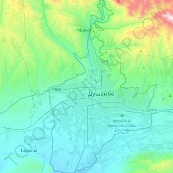
Name: Dushanbe topographic map, elevation, terrain.
Location: Dushanbe, 734000, Tajikistan (38.46448 68.68883 38.70684 68.88710)
Average elevation: 1,016 m
Minimum elevation: 705 m
Maximum elevation: 2,530 m
Other topographic maps
Click on a map to view its topography, its elevation and its terrain.