
Mount Hayes topographic map
Interactive map
Click on the map to display elevation.
About this map
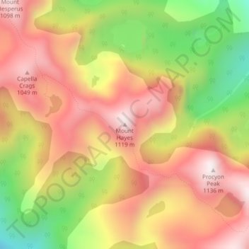
Name: Mount Hayes topographic map, elevation, terrain.
Location: Mount Hayes, Tasmanien, Australien (-43.13247 146.24718 -43.13237 146.24728)
Average elevation: 768 m
Minimum elevation: 335 m
Maximum elevation: 1,089 m
Other topographic maps
Click on a map to view its topography, its elevation and its terrain.
Sterling River
Australien > Tasmanien > Tullah
Sterling River, Tullah, West Coast, Tasmanien, Australien
Average elevation: 246 m
Glenorchy
Australien > Tasmanien > Glenorchy
Glenorchy, Tasmanien, 7010, Australien
Average elevation: 122 m
Mount Arrowsmith
Mount Arrowsmith, Tasmanien, Australien
Average elevation: 761 m
Lake St Clair
Australien > Tasmanien > Lake St Clair
Lake St Clair, Tasmanien, Australien
Average elevation: 774 m