
Make a donation
Loch Lochy topographic map
Click on the map to display elevation.
Make a donation
About this map
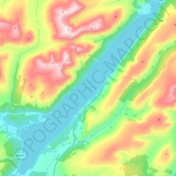
Name: Loch Lochy topographic map, elevation, terrain.
Location: Loch Lochy, Highland, Scotland, United Kingdom (56.91442 -4.99391 57.02659 -4.82343)
Average elevation: 363 m
Minimum elevation: 22 m
Maximum elevation: 930 m
Make a donation
Other topographic maps
Click on a map to view its topography, its elevation and its terrain.
Make a donation
Make a donation
Ben More Assynt
United Kingdom > Scotland > Highland
In 2012, the Commonwealth War Graves Commission decided to replace the existing cairn, which had deteriorated in the harsh climate, with a 600-kilogramme granite marker to identify and protect the burial site. At an elevation of around 600 m (2,000 ft), the burial site on Ben More Assynt is one of the…
Average elevation: 679 m
Make a donation
Aonach Beag
United Kingdom > Scotland > Highland
Aonach Beag is linked to its close neighbour to the north, Aonach Mòr, by a high saddle or bealach. The name Aonach Beag (small ridge) might imply that this mountain is smaller than Aonach Mòr (big ridge). However, Aonach Beag is higher; the names refer to the relative bulk of the two mountains rather than…
Average elevation: 825 m
Make a donation
Make a donation