
Bulusan topographic map
Interactive map
Click on the map to display elevation.
About this map
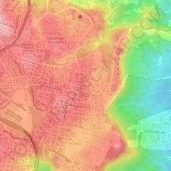
Name: Bulusan topographic map, elevation, terrain.
Location: Bulusan, Tembalang, Semarang, Java central, 50277, Indonésie (-7.06913 110.43577 -7.04944 110.46500)
Average elevation: 140 m
Minimum elevation: 36 m
Maximum elevation: 217 m
Other topographic maps
Click on a map to view its topography, its elevation and its terrain.
Karangtempel
Indonésie > Java central > Semarang
Karangtempel, Semarang Timur, Semarang, Java central, 50125, Indonésie
Average elevation: 9 m
Karanganyar
Indonésie > Java central > Semarang
Karanganyar, Tugu, Semarang, Java central, Indonésie
Average elevation: 7 m