
Sidama topographic map
Interactive map
Click on the map to display elevation.
About this map
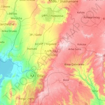
Name: Sidama topographic map, elevation, terrain.
Location: Sidama, Nations du Sud, Éthiopie (6.14102 38.00185 7.16744 39.13518)
Average elevation: 2,069 m
Minimum elevation: 1,174 m
Maximum elevation: 3,303 m
Other topographic maps
Click on a map to view its topography, its elevation and its terrain.
Emdibir
Éthiopie > Nations du Sud > Emdibir
Emdibir, Guraghe, Nations du Sud, Éthiopie
Average elevation: 2,084 m
Kembata Alaba Tembaro
Kembata Alaba Tembaro, Nations du Sud, Éthiopie
Average elevation: 1,913 m