
Hadiya topographic map
Interactive map
Click on the map to display elevation.
About this map
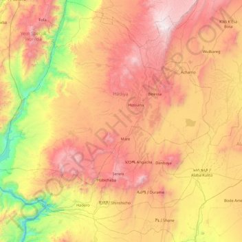
Name: Hadiya topographic map, elevation, terrain.
Location: Hadiya, Nations du Sud, Éthiopie (7.06508 37.33377 7.91935 38.13488)
Average elevation: 1,949 m
Minimum elevation: 756 m
Maximum elevation: 3,264 m
Other topographic maps
Click on a map to view its topography, its elevation and its terrain.
Emdibir
Éthiopie > Nations du Sud > Emdibir
Emdibir, Guraghe, Nations du Sud, Éthiopie
Average elevation: 2,084 m
Kembata Alaba Tembaro
Kembata Alaba Tembaro, Nations du Sud, Éthiopie
Average elevation: 1,913 m