
Warstein topographic map
Interactive map
Click on the map to display elevation.
About this map
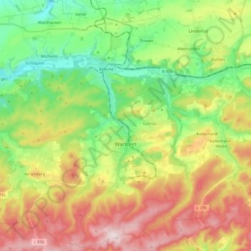
Name: Warstein topographic map, elevation, terrain.
Location: Warstein, Kreis Soest, Noordrijn-Westfalen, 59581, Duitsland (51.38855 8.20178 51.52277 8.40984)
Average elevation: 373 m
Minimum elevation: 223 m
Maximum elevation: 582 m
Other topographic maps
Click on a map to view its topography, its elevation and its terrain.
Rüthen
Duitsland > Noordrijn-Westfalen > Kreis Soest
Rüthen, Kreis Soest, Noordrijn-Westfalen, 59602, Duitsland
Average elevation: 320 m
Geseke
Duitsland > Noordrijn-Westfalen > Kreis Soest > Geseke
Geseke, Kreis Soest, Noordrijn-Westfalen, 59590, Duitsland
Average elevation: 149 m
Soest
Duitsland > Noordrijn-Westfalen > Kreis Soest
Soest, Kreis Soest, Noordrijn-Westfalen, 59494, Duitsland
Average elevation: 121 m
Bad Sassendorf
Duitsland > Noordrijn-Westfalen > Kreis Soest
Bad Sassendorf, Kreis Soest, Noordrijn-Westfalen, 59505, Duitsland
Average elevation: 125 m
Heppen
Duitsland > Noordrijn-Westfalen > Kreis Soest > Bad Sassendorf
Heppen, Bad Sassendorf, Kreis Soest, Noordrijn-Westfalen, Duitsland
Average elevation: 92 m