
Fichtelberg topographic map
Interactive map
Click on the map to display elevation.
About this map
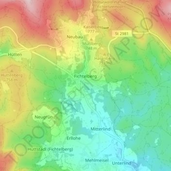
Name: Fichtelberg topographic map, elevation, terrain.
Location: Fichtelberg, Landkreis Bayreuth, Bavaria, 95686, Germany (49.97317 11.82764 50.02111 11.87379)
Average elevation: 697 m
Minimum elevation: 589 m
Maximum elevation: 875 m
The history of the site at Fichtelberg is dominated by ore mining of the mining company Erzgrube Gottesgab im Gleißingerfels am Fichtelberg. In 1600 the uppermost reaches of the Fichtelnaab valley near the present villages of Neubau and Fichtelberg was still covered with a rugged, forest-covered wilderness. Finds, such as a serpentine pendant in 1922 on the Ochsenkopf or a stone axe head excavated in 1935 east of Fichtelberg, suggest that the area around Fichtelberg was already inhabited in the Neolithic period, at least by hunters passing through. The absence of other finds, however, rules out any permanent settlement until the beginning of the 17th century. This was probably due to the steep slopes and significantly higher altitude along with a harsh climate and less fertile soils. Iron ore mining in the upper Fichtelnaab valley began in 1478, but only a small settlement of a few houses extended from the south up to the outskirts of what is now Fichtelberg today.
Other topographic maps
Click on a map to view its topography, its elevation and its terrain.
Gottelhof
Germany > Bavaria > Landkreis Bayreuth > Hollfeld
Gottelhof, Hollfeld, Hollfeld (VGem), Landkreis Bayreuth, Bavaria, 95515, Germany
Average elevation: 407 m
Röhrig
Germany > Bavaria > Landkreis Bayreuth > Bindlacher Berg
Röhrig, Bindlacher Berg, Bindlach, Landkreis Bayreuth, Bavaria, 95463, Germany
Average elevation: 410 m
Gefrees
Germany > Bavaria > Landkreis Bayreuth
Gefrees, Landkreis Bayreuth, Bavaria, 95482, Germany
Average elevation: 585 m
Plech
Germany > Bavaria > Landkreis Bayreuth
Plech, Betzenstein (VGem), Landkreis Bayreuth, Bavaria, 91287, Germany
Average elevation: 475 m