
Aggenstein topographic map
Interactive map
Click on the map to display elevation.
About this map
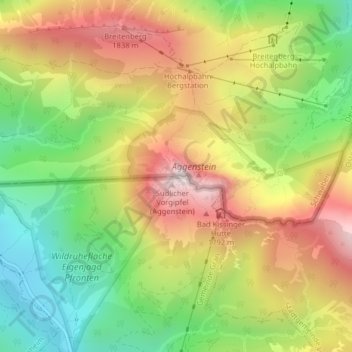
Name: Aggenstein topographic map, elevation, terrain.
Average elevation: 1,478 m
Minimum elevation: 1,068 m
Maximum elevation: 1,932 m
Die Schartenhöhe des Aggensteins beträgt mindestens 266 Meter, seine Dominanz 1,8 Kilometer, wobei jeweils das Brentenjoch Referenzberg ist.
Other topographic maps
Click on a map to view its topography, its elevation and its terrain.
Tannheimer Tal
Österreich > Tirol > Bezirk Reutte > Gemeinde Grän
Tannheimer Tal, Gemeinde Grän, Bezirk Reutte, Tirol, 6671, Österreich
Average elevation: 1,433 m
Haldensee
Österreich > Tirol > Bezirk Reutte > Gemeinde Grän
Haldensee, Gemeinde Grän, Bezirk Reutte, Tirol, 6673, Österreich
Average elevation: 1,371 m