
Somerset County topographic map
Interactive map
Click on the map to display elevation.
About this map
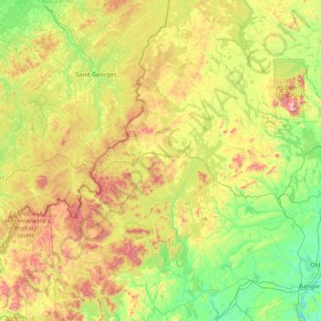
Name: Somerset County topographic map, elevation, terrain.
Location: Somerset County, Maine, United States (44.57732 -70.55287 46.57407 -69.26672)
Average elevation: 362 m
Minimum elevation: -3 m
Maximum elevation: 1,577 m
Other topographic maps
Click on a map to view its topography, its elevation and its terrain.
Warren
United States > Maine > Knox County
Warren, Knox County, Maine, 04864, United States
Average elevation: 47 m
Waterville
United States > Maine > Kennebec County > Waterville
Waterville, Kennebec County, Maine, United States
Average elevation: 54 m
Portland
United States > Maine > Cumberland County > Portland
Portland, Cumberland County, Maine, United States
Average elevation: 16 m
Bangor
United States > Maine > Penobscot County > Bangor
Bangor, Penobscot County, Maine, 04401, United States
Average elevation: 42 m