
Wisembach topographic map
Interactive map
Click on the map to display elevation.
About this map
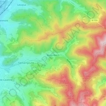
Name: Wisembach topographic map, elevation, terrain.
Average elevation: 607 m
Minimum elevation: 380 m
Maximum elevation: 954 m
Wisembach est située au pied du col de Sainte-Marie (772 mètres d'altitude) qui s'ouvre sur l'Alsace, à 14 kilomètres de Saint-Dié sur la route départementale 459 reliant Sélestat à Nancy.
Other topographic maps
Click on a map to view its topography, its elevation and its terrain.
Morelmaison
Morelmaison, Neufchâteau, Vosges, Grand Est, France métropolitaine, 88170, France
Average elevation: 321 m
Rue du Mont
France > Grand Est > Vosges > Chamagne
Rue du Mont, Chamagne, Épinal, Vosges, Grand Est, France métropolitaine, 88130, France
Average elevation: 268 m
Neufchâteau
Neufchâteau, Vosges, Grand Est, France métropolitaine, 88300, France
Average elevation: 334 m
Saint-Dié-des-Vosges
France > Grand Est > Vosges > Saint-Dié-des-Vosges
Saint-Dié-des-Vosges, Vosges, Grand Est, France métropolitaine, 88100, France
Average elevation: 433 m