
Make a donation
Caringo Island topographic map
Click on the map to display elevation.
Make a donation
About this map
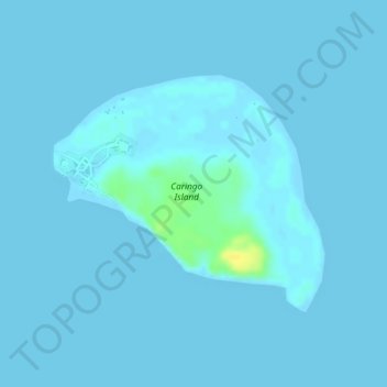
Name: Caringo Island topographic map, elevation, terrain.
Location: Caringo Island, Camarines Norte, Bicol Region, Philippines (14.03029 123.09415 14.04685 123.11367)
Average elevation: 1 m
Minimum elevation: -1 m
Maximum elevation: 23 m
Make a donation
Other topographic maps
Click on a map to view its topography, its elevation and its terrain.
Make a donation
Make a donation
Talisay
The fertile soil, topography (averaging about 10 metres (33 ft) above sea-level) and suitable climate are the main reasons why agriculture is the economic backbone of the town. Rice and coconut farming are the major agricultural activities for most of the barangays and fishing is the second thriving industry…
Average elevation: 10 m
Make a donation
Daet
Daet is located in the southeastern part of Camarines Norte. It is bounded in the east by the town of Mercedes; in the south by the municipality of Basud; in southwest by San Lorenzo Ruiz town; in the north by Pacific Ocean; in the west by San Vicente and northwest by Talisay. The provincial capital covers a…
Average elevation: 6 m
Make a donation
Make a donation
Make a donation
Make a donation
Make a donation
Make a donation
Make a donation
Make a donation
Make a donation
Make a donation
Make a donation
Make a donation
Make a donation
Make a donation
Daet
Daet is located in the southeastern part of Camarines Norte. It is bounded in the east by the town of Mercedes; in the south by the municipality of Basud; in southwest by San Lorenzo Ruiz town; in the north by Pacific Ocean; in the west by San Vicente and northwest by Talisay. The provincial capital covers a…
Average elevation: 6 m
Make a donation
Make a donation
Make a donation
Daet
Daet is located in the southeastern part of Camarines Norte. It is bounded in the east by the town of Mercedes; in the south by the municipality of Basud; in southwest by San Lorenzo Ruiz town; in the north by Pacific Ocean; in the west by San Vicente and northwest by Talisay. The provincial capital covers a…
Average elevation: 6 m
Make a donation