
Make a donation
Sta. Elena topographic map
Click on the map to display elevation.
Make a donation
About this map
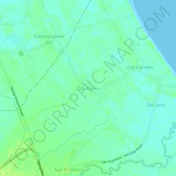
Name: Sta. Elena topographic map, elevation, terrain.
Location: Sta. Elena, Camarines Norte, Bicol Region, 4603, Philippines (14.14013 122.91227 14.18013 122.95227)
Average elevation: 5 m
Minimum elevation: 0 m
Maximum elevation: 13 m
Make a donation
Other topographic maps
Click on a map to view its topography, its elevation and its terrain.
Daet
Daet is located in the southeastern part of Camarines Norte. It is bounded in the east by the town of Mercedes; in the south by the municipality of Basud; in southwest by San Lorenzo Ruiz town; in the north by Pacific Ocean; in the west by San Vicente and northwest by Talisay. The provincial capital covers a…
Average elevation: 6 m
Make a donation
Make a donation
Daet
Daet is located in the southeastern part of Camarines Norte. It is bounded in the east by the town of Mercedes; in the south by the municipality of Basud; in southwest by San Lorenzo Ruiz town; in the north by Pacific Ocean; in the west by San Vicente and northwest by Talisay. The provincial capital covers a…
Average elevation: 6 m
Make a donation
Daet
Daet is located in the southeastern part of Camarines Norte. It is bounded in the east by the town of Mercedes; in the south by the municipality of Basud; in southwest by San Lorenzo Ruiz town; in the north by Pacific Ocean; in the west by San Vicente and northwest by Talisay. The provincial capital covers a…
Average elevation: 6 m