
Thank you for supporting this site ❤️
Make a donation
Make a donation
Lucca topographic map
Click on the map to display elevation.
Thank you for supporting this site ❤️
Make a donation
Make a donation
About this map
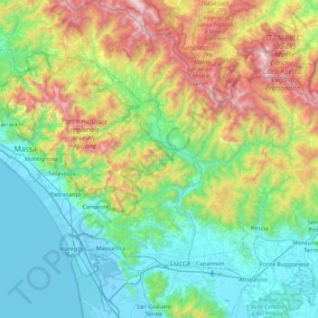
Name: Lucca topographic map, elevation, terrain.
Location: Lucca, Tuscany, Italy (43.74934 10.14336 44.28617 10.73755)
Average elevation: 560 m
Minimum elevation: -5 m
Maximum elevation: 2,139 m
Thank you for supporting this site ❤️
Make a donation
Make a donation
Other topographic maps
Click on a map to view its topography, its elevation and its terrain.
Thank you for supporting this site ❤️
Make a donation
Make a donation
Thank you for supporting this site ❤️
Make a donation
Make a donation