
Thank you for supporting this site ❤️
Make a donation
Make a donation
Strasburg (Uckermark) topographic map
Click on the map to display elevation.
Thank you for supporting this site ❤️
Make a donation
Make a donation
About this map
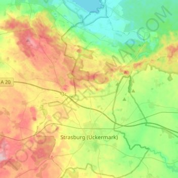
Name: Strasburg (Uckermark) topographic map, elevation, terrain.
Average elevation: 68 m
Minimum elevation: 6 m
Maximum elevation: 164 m
Thank you for supporting this site ❤️
Make a donation
Make a donation
Other topographic maps
Click on a map to view its topography, its elevation and its terrain.
Riemserort
Germany > Mecklenburg-Vorpommern > Vorpommern-Greifswald > Greifswald
Average elevation: 1 m
Greifswald
Germany > Mecklenburg-Vorpommern > Vorpommern-Greifswald > Greifswald > Greifswald
Average elevation: 6 m
Thank you for supporting this site ❤️
Make a donation
Make a donation
Löcknitz
Germany > Mecklenburg-Vorpommern > Vorpommern-Greifswald > Löcknitz > Löcknitz
Average elevation: 13 m
Bismark
Germany > Mecklenburg-Vorpommern > Vorpommern-Greifswald > Ramin > Bismark
Average elevation: 36 m