
Make a donation
Johnson County topographic map
Click on the map to display elevation.
Make a donation
Johnson County
The natural topography of the county consists of gently rolling terrain. The Kansas River forms a portion of the northwest boundary of the county. The elevation generally increases from north to south as the distance from the Kansas and Missouri rivers increases.
Make a donation
About this map
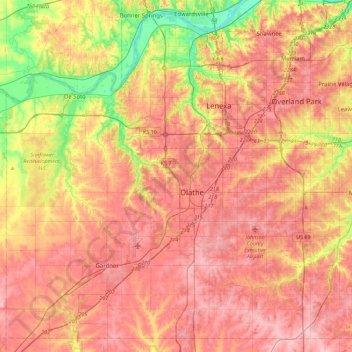
Name: Johnson County topographic map, elevation, terrain.
Location: Johnson County, Kansas, United States (38.73810 -95.05650 39.06166 -94.60738)
Average elevation: 297 m
Minimum elevation: 221 m
Maximum elevation: 347 m
Make a donation
Other topographic maps
Click on a map to view its topography, its elevation and its terrain.
Make a donation
Mount Sunflower
United States > Kansas > Wallace County
Mount Sunflower, although not a true mountain, is the highest natural point in the U.S. state of Kansas. At 4,039 feet (1,231 m), it is 3,300 feet (1,010 m) above the state's topographic low point, which lies on the opposite side of the state. It is located between the communities of Kanorado and Weskan in…
Average elevation: 1,215 m
Make a donation
Make a donation