
Darrang topographic map
Interactive map
Click on the map to display elevation.
About this map
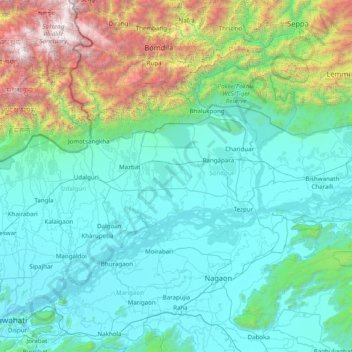
Name: Darrang topographic map, elevation, terrain.
Location: Darrang, Sonitpur, Assam, 784110, India (26.05000 91.80000 27.45000 93.20000)
Average elevation: 697 m
Minimum elevation: 43 m
Maximum elevation: 4,451 m
Other topographic maps
Click on a map to view its topography, its elevation and its terrain.
Kaziranga National Park and Tiger Reserve
Kaziranga National Park and Tiger Reserve, Bokakhat, Golaghat District, Assam, India
Average elevation: 202 m
North Lakhimpur
North Lakhimpur, Lakhimpur, Assam, India
Average elevation: 96 m
Numaligarh
India > Assam > Bokakhat > Numaligarh
Numaligarh, Bokakhat, Golaghat, Assam, 785615, India
Average elevation: 87 m
Mahatma Gandhi Park
Mahatma Gandhi Park, Chowk Bazar, Atila Gaon, Jorhat, Assam, India
Average elevation: 92 m