
Blauen topographic map
Interactive map
Click on the map to display elevation.
About this map
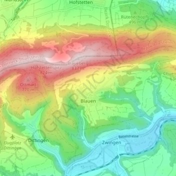
Name: Blauen topographic map, elevation, terrain.
Location: Blauen, Bezirk Laufen, Basel-Landschaft, 4223, Schweiz (47.44103 7.48453 47.46369 7.55467)
Average elevation: 529 m
Minimum elevation: 330 m
Maximum elevation: 831 m
Other topographic maps
Click on a map to view its topography, its elevation and its terrain.
Laufen
Schweiz > Basel-Landschaft > Bezirk Laufen
Laufen, Bezirk Laufen, Basel-Landschaft, 4242, Schweiz
Average elevation: 455 m
Duggingen
Schweiz > Basel-Landschaft > Bezirk Laufen
Duggingen, Bezirk Laufen, Basel-Landschaft, 4202, Schweiz
Average elevation: 463 m