
Duggingen topographic map
Interactive map
Click on the map to display elevation.
About this map
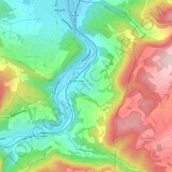
Name: Duggingen topographic map, elevation, terrain.
Location: Duggingen, Bezirk Laufen, Basel-Landschaft, 4202, Schweiz (47.43270 7.59393 47.47045 7.62607)
Average elevation: 463 m
Minimum elevation: 298 m
Maximum elevation: 704 m
Other topographic maps
Click on a map to view its topography, its elevation and its terrain.
Laufen
Schweiz > Basel-Landschaft > Bezirk Laufen
Laufen, Bezirk Laufen, Basel-Landschaft, 4242, Schweiz
Average elevation: 455 m
Blauen
Schweiz > Basel-Landschaft > Bezirk Laufen
Blauen, Bezirk Laufen, Basel-Landschaft, 4223, Schweiz
Average elevation: 529 m