
Thank you for supporting this site ❤️
Make a donation
Make a donation
Siena topographic map
Click on the map to display elevation.
Thank you for supporting this site ❤️
Make a donation
Make a donation
About this map
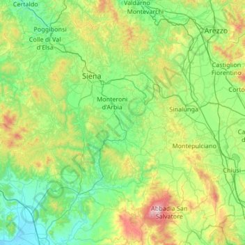
Name: Siena topographic map, elevation, terrain.
Location: Siena, Tuscany, Italy (42.78578 10.90831 43.54846 11.98280)
Average elevation: 335 m
Minimum elevation: -2 m
Maximum elevation: 1,716 m
Thank you for supporting this site ❤️
Make a donation
Make a donation
Other topographic maps
Click on a map to view its topography, its elevation and its terrain.
Thank you for supporting this site ❤️
Make a donation
Make a donation
Thank you for supporting this site ❤️
Make a donation
Make a donation