
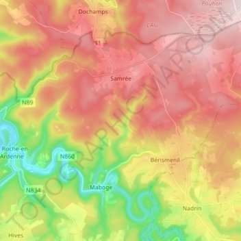
Samrée topographic map
Interactive map
Click on the map to display elevation.
About this map
Name: Samrée topographic map, elevation, terrain.
Average elevation: 450 m
Minimum elevation: 211 m
Maximum elevation: 642 m
Other topographic maps
Click on a map to view its topography, its elevation and its terrain.
Érezée
Belgien > Luxemburg > Marche-en-Famenne
Érezée, Marche-en-Famenne, Luxemburg, Wallonien, 6997, Belgien
Average elevation: 326 m
Marche-en-Famenne
Belgien > Luxemburg > Marche-en-Famenne > Marche-en-Famenne
Marche-en-Famenne, Luxemburg, Wallonien, 6900, Belgien
Average elevation: 252 m
Durbuy
Belgien > Luxemburg > Marche-en-Famenne
Durbuy, Marche-en-Famenne, Luxemburg, Wallonien, Belgien
Average elevation: 244 m