
Érezée topographic map
Interactive map
Click on the map to display elevation.
About this map
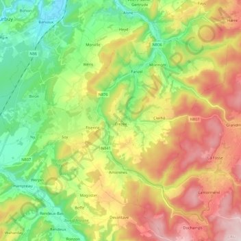
Name: Érezée topographic map, elevation, terrain.
Location: Érezée, Marche-en-Famenne, Luxemburg, Wallonien, 6997, Belgien (50.24693 5.44102 50.34220 5.65490)
Average elevation: 326 m
Minimum elevation: 132 m
Maximum elevation: 597 m
Other topographic maps
Click on a map to view its topography, its elevation and its terrain.
Samrée
Belgien > Luxemburg > Marche-en-Famenne
Samrée, La Roche-en-Ardenne, Marche-en-Famenne, Luxemburg, Wallonien, 6982, Belgien
Average elevation: 450 m
Marche-en-Famenne
Belgien > Luxemburg > Marche-en-Famenne > Marche-en-Famenne
Marche-en-Famenne, Luxemburg, Wallonien, 6900, Belgien
Average elevation: 252 m
Durbuy
Belgien > Luxemburg > Marche-en-Famenne
Durbuy, Marche-en-Famenne, Luxemburg, Wallonien, Belgien
Average elevation: 244 m