
Le Moi topographic map
Interactive map
Click on the map to display elevation.
About this map
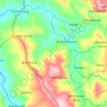
Name: Le Moi topographic map, elevation, terrain.
Location: Le Moi, West Nias, North Sumatra, Indonesia (1.04834 97.55499 1.10562 97.61837)
Average elevation: 203 m
Minimum elevation: 49 m
Maximum elevation: 443 m
Other topographic maps
Click on a map to view its topography, its elevation and its terrain.
City of Medan
City of Medan, North Sumatra, Sumatra, Indonesia
Average elevation: 18 m
Medan
Medan, City of Medan, North Sumatra, Sumatra, Indonesia
Average elevation: 32 m
North Tapanuli
North Tapanuli, North Sumatra, Indonesia
Average elevation: 983 m
Gunung Sinabung
Indonesia > North Sumatra > Karo
Gunung Sinabung, Karo, North Sumatra, Indonesia
Average elevation: 1,835 m
Pangkalan Brandan
Indonesia > North Sumatra > Langkat > Pangkalan Brandan
Pangkalan Brandan, Langkat, North Sumatra, Indonesia
Average elevation: 4 m
Gondia
Indonesia > North Sumatra > South Nias > Gondia
Gondia, South Nias, North Sumatra, Indonesia
Average elevation: 5 m
Tebing Tinggi
Indonesia > North Sumatra > Tebing Tinggi
Tebing Tinggi, Kota Tebing Tinggi–Serdang Bedagai, North Sumatra, 20600, Indonesia
Average elevation: 34 m
Dolok Simanukmanuk
Indonesia > North Sumatra > Pematang Siantar
Dolok Simanukmanuk, Pematang Siantar, North Sumatra, Indonesia
Average elevation: 1,785 m