
Thank you for supporting this site ❤️
Make a donation
Make a donation
Ouren topographic map
Click on the map to display elevation.
Thank you for supporting this site ❤️
Make a donation
Make a donation
About this map
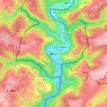
Name: Ouren topographic map, elevation, terrain.
Location: Ouren, Burg-Reuland, Verviers, Liège, Wallonia, Belgium (50.11884 6.11380 50.15884 6.15380)
Average elevation: 428 m
Minimum elevation: 318 m
Maximum elevation: 514 m
Thank you for supporting this site ❤️
Make a donation
Make a donation
Other topographic maps
Click on a map to view its topography, its elevation and its terrain.