
Make a donation
Ilha do Pico topographic map
Click on the map to display elevation.
Make a donation
Ilha do Pico
Pico Island (Ilha do Pico, Portuguese pronunciation: [ˈiʎɐ ðu ˈpiku]) is an island in the Central Group of the Portuguese Azores. The landscape features an eponymous volcano, Ponta do Pico, which is the highest mountain in Portugal, the Azores, and the highest elevation of the Mid-Atlantic Ridge. In the tradition of the Portuguese poet, Raul Brandão, Pico is referred to as the Ilha Preta ("Black Island"), for its black volcanic soils, which nourish its UNESCO-designated vineyards that once allowed the development of the island's economy. Pico is the second largest and, geologically speaking, the most recently formed island of the Azores, being around 300,000 years old.
Make a donation
About this map
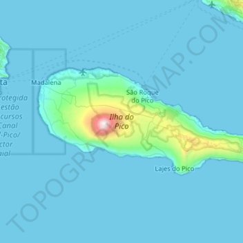
Name: Ilha do Pico topographic map, elevation, terrain.
Location: Ilha do Pico, Azores, Portugal (38.38207 -28.54190 38.56143 -28.02820)
Average elevation: 104 m
Minimum elevation: 0 m
Maximum elevation: 2,279 m
Make a donation
Other topographic maps
Click on a map to view its topography, its elevation and its terrain.
Make a donation
Make a donation
Make a donation
Montemor
Portugal > Évora > Nossa Senhora da Vila, Nossa Senhora do Bispo e Silveiras
Average elevation: 222 m
Make a donation
Make a donation