
Oberengstringen topographic map
Interactive map
Click on the map to display elevation.
About this map
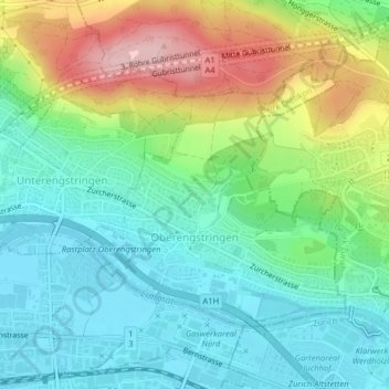
Name: Oberengstringen topographic map, elevation, terrain.
Location: Oberengstringen, Bezirk Dietikon, Zürich, 8102, Schweiz (47.40294 8.45167 47.42115 8.47819)
Average elevation: 462 m
Minimum elevation: 388 m
Maximum elevation: 620 m
Other topographic maps
Click on a map to view its topography, its elevation and its terrain.
Aesch (ZH)
Schweiz > Zürich > Bezirk Dietikon > Aesch (ZH)
Aesch (ZH), Bezirk Dietikon, Zürich, 8904, Schweiz
Average elevation: 580 m
Dietikon
Schweiz > Zürich > Bezirk Dietikon
Dietikon, Bezirk Dietikon, Zürich, 8953, Schweiz
Average elevation: 458 m
Uitikon
Schweiz > Zürich > Bezirk Dietikon > Uitikon
Uitikon, Bezirk Dietikon, Zürich, 8142, Schweiz
Average elevation: 542 m
Urdorf
Schweiz > Zürich > Bezirk Dietikon > Urdorf
Urdorf, Bezirk Dietikon, Zürich, 8902, Schweiz
Average elevation: 475 m