
Schmelz topographic map
Interactive map
Click on the map to display elevation.
About this map
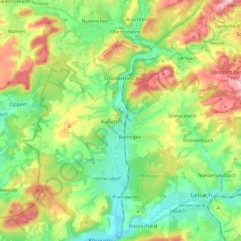
Name: Schmelz topographic map, elevation, terrain.
Location: Schmelz, Landkreis Saarlouis, Saarland, 66839, Deutschland (49.39221 6.78535 49.50172 6.93677)
Average elevation: 290 m
Minimum elevation: 198 m
Maximum elevation: 450 m
Other topographic maps
Click on a map to view its topography, its elevation and its terrain.
Bisten
Deutschland > Saarland > Landkreis Saarlouis > Überherrn
Bisten, Überherrn, Landkreis Saarlouis, Saarland, Deutschland
Average elevation: 228 m
Lebach
Deutschland > Saarland > Landkreis Saarlouis
Lebach, Landkreis Saarlouis, Saarland, 66822, Deutschland
Average elevation: 295 m
Überherrn
Deutschland > Saarland > Landkreis Saarlouis
Überherrn, Landkreis Saarlouis, Saarland, 66802, Deutschland
Average elevation: 244 m