
Make a donation
Catalonia topographic map
Click on the map to display elevation.
Make a donation
Catalonia
In the Mediterranean area, summers are dry and hot with sea breezes, and the maximum temperature is around 26–31 °C (79–88 °F). Winter is cool or slightly cold depending on the location. It snows frequently in the Pyrenees, and it occasionally snows at lower altitudes, even by the coastline. Spring and autumn are typically the rainiest seasons, except for the Pyrenean valleys, where summer is typically stormy.
Make a donation
About this map
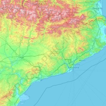
Name: Catalonia topographic map, elevation, terrain.
Location: Catalonia, Spain (40.52298 0.15941 42.86152 3.32225)
Average elevation: 559 m
Minimum elevation: -5 m
Maximum elevation: 3,311 m
Make a donation
Other topographic maps
Click on a map to view its topography, its elevation and its terrain.
Make a donation
Make a donation
Make a donation
Puente de Domingo Flórez
Spain > Castile and León > El Bierzo > Puente de Domingo Flórez
Average elevation: 527 m
Make a donation
Foronda
Spain > Autonomous Community of the Basque Country > Gasteizko kuadrilla/Cuadrilla de Vitoria > Vitoria-Gasteiz
Average elevation: 525 m
Make a donation
Castillo de Peñiscola
Spain > Valencian Community > Castelló / Castellón > Peníscola / Peñíscola
The castle is situated on a crag overlooking the Mediterranean Sea, at an altitude of 64 metres (210 ft) above mean sea level.
Average elevation: 5 m
Make a donation
Make a donation
Make a donation
Make a donation
Madrid
Spain > Community of Madrid > Área metropolitana de Madrid y Corredor del Henares > Madrid
Average elevation: 650 m
Vigo
Vigo has a warm-summer Mediterranean climate "Csb" according to the Köppen climate classification. Although Vigo is the rainiest city in Galicia, nowadays, with its noticeable drying trend in the summer, Vigo's climate is more similar to the variant of the oceanic climate commonly seen in the Pacific…
Average elevation: 121 m
Make a donation
Murcia
Spain > Region of Murcia > Área Metropolitana de Murcia > Murcia
Murcia is located near the center of a low-lying fertile plain known as the huerta (orchard or vineyard) of Murcia. The Segura River and its right-hand tributary, the Guadalentín, run through the area. The city has an elevation of 43 metres (141 ft) above sea level and its municipality covers approximately…
Average elevation: 169 m
Make a donation
Biañez
Spain > Autonomous Community of the Basque Country > Karrantza Harana / Valle de Carranza > Biañez
Average elevation: 232 m
Pollença
Spain > Balearic Islands > Serra de Tramuntana > Pollença > Pollença
Average elevation: 156 m
Make a donation
Make a donation