
Thank you for supporting this site ❤️
Make a donation
Make a donation
Marshall County topographic map
Click on the map to display elevation.
Thank you for supporting this site ❤️
Make a donation
Make a donation
About this map
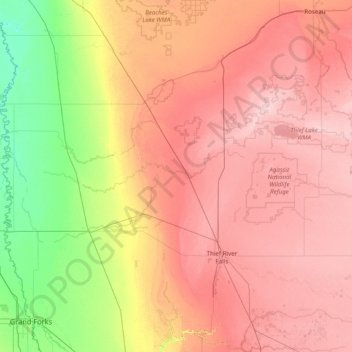
Name: Marshall County topographic map, elevation, terrain.
Location: Marshall County, Minnesota, United States (48.17292 -97.16409 48.54514 -95.59212)
Average elevation: 307 m
Minimum elevation: 235 m
Maximum elevation: 378 m
Thank you for supporting this site ❤️
Make a donation
Make a donation
Other topographic maps
Click on a map to view its topography, its elevation and its terrain.
Minneapolis
United States > Minnesota > Hennepin County > Minneapolis
A 1959 report by the U.S. Soil Conservation Service listed Minneapolis's elevation as 830 feet (250 m). The city's lowest elevation of 687 feet (209 m) above sea level is near where Minnehaha Creek meets the Mississippi River. Sources disagree on the exact location and elevation of the city's highest point,…
Average elevation: 271 m
Thank you for supporting this site ❤️
Make a donation
Make a donation