
Red Lake County topographic map
Interactive map
Click on the map to display elevation.
Red Lake County
The Red Lake River flows southward into the county from Pennington County. It is joined near Red Lake Falls by the Clearwater River; the combined flow (still known as the Red Lake River) flows southwestward to Huot, where it is augmented by the Black River, which drains the northwestern part of the county. The Red Lake River then flows southwestward into Polk County. The county terrain consists of low rolling hills, etched by drainages and gullies. The area is devoted to agriculture. The county terrain slopes to the west, with its highest elevation on its southeastern corner, at 1,201 ft (366 m) ASL. The county has a total area of 432 square miles (1,120 km2), of which 432 square miles (1,120 km2) is land and 0.09 square miles (0.23 km2) (0.02%) is water.
About this map
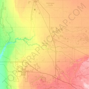
Name: Red Lake County topographic map, elevation, terrain.
Location: Red Lake County, Minnesota, United States (47.75957 -96.48255 47.96464 -95.70915)
Average elevation: 341 m
Minimum elevation: 268 m
Maximum elevation: 419 m
Other topographic maps
Click on a map to view its topography, its elevation and its terrain.
Minneapolis
United States > Minnesota > Hennepin County > Minneapolis
A 1959 report by the U.S. Soil Conservation Service listed Minneapolis's elevation as 830 feet (250 m). The city's lowest elevation of 687 feet (209 m) above sea level is near where Minnehaha Creek meets the Mississippi River. Sources disagree on the exact location and elevation of the city's highest point,…
Average elevation: 271 m