
Thank you for supporting this site ❤️
Make a donation
Make a donation
Vellad topographic map
Click on the map to display elevation.
Thank you for supporting this site ❤️
Make a donation
Make a donation
About this map
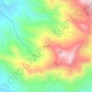
Name: Vellad topographic map, elevation, terrain.
Location: Vellad, Taliparamba, Kannur District, Kerala, 670582, India (12.12577 75.48574 12.16577 75.52574)
Average elevation: 381 m
Minimum elevation: 60 m
Maximum elevation: 790 m
Thank you for supporting this site ❤️
Make a donation
Make a donation
Other topographic maps
Click on a map to view its topography, its elevation and its terrain.
Thank you for supporting this site ❤️
Make a donation
Make a donation
Thank you for supporting this site ❤️
Make a donation
Make a donation
Thank you for supporting this site ❤️
Make a donation
Make a donation