
Thank you for supporting this site ❤️
Make a donation
Make a donation
Seegehalli topographic map
Click on the map to display elevation.
Thank you for supporting this site ❤️
Make a donation
Make a donation
About this map
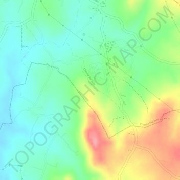
Name: Seegehalli topographic map, elevation, terrain.
Location: Seegehalli, Bangalore South, Bengaluru Urban, Karnataka, India (12.80733 77.44762 12.82179 77.46499)
Average elevation: 746 m
Minimum elevation: 707 m
Maximum elevation: 808 m
Thank you for supporting this site ❤️
Make a donation
Make a donation
Other topographic maps
Click on a map to view its topography, its elevation and its terrain.
Thank you for supporting this site ❤️
Make a donation
Make a donation
Thank you for supporting this site ❤️
Make a donation
Make a donation
Thank you for supporting this site ❤️
Make a donation
Make a donation
Thank you for supporting this site ❤️
Make a donation
Make a donation
Ramasandra
India > Karnataka > Bangalore South > Archakara Badavane > Ramasandra
Average elevation: 796 m
Thank you for supporting this site ❤️
Make a donation
Make a donation
Thank you for supporting this site ❤️
Make a donation
Make a donation