
Thank you for supporting this site ❤️
Make a donation
Make a donation
Ganakallu topographic map
Click on the map to display elevation.
Thank you for supporting this site ❤️
Make a donation
Make a donation
About this map
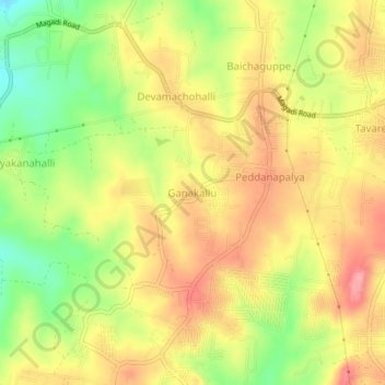
Name: Ganakallu topographic map, elevation, terrain.
Location: Ganakallu, Bangalore South, Bangalore Urban, Karnataka, India (12.93699 77.36119 12.97699 77.40119)
Average elevation: 845 m
Minimum elevation: 784 m
Maximum elevation: 892 m
Thank you for supporting this site ❤️
Make a donation
Make a donation
Other topographic maps
Click on a map to view its topography, its elevation and its terrain.
Thank you for supporting this site ❤️
Make a donation
Make a donation
Thank you for supporting this site ❤️
Make a donation
Make a donation
Thank you for supporting this site ❤️
Make a donation
Make a donation
Thank you for supporting this site ❤️
Make a donation
Make a donation
Thank you for supporting this site ❤️
Make a donation
Make a donation
Thank you for supporting this site ❤️
Make a donation
Make a donation