
Thank you for supporting this site ❤️
Make a donation
Make a donation
Palo Alto topographic map
Click on the map to display elevation.
Thank you for supporting this site ❤️
Make a donation
Make a donation
Palo Alto
The official elevation is 30 feet (9 m) above sea level, but the city boundaries reach well into the northern section of the Santa Cruz Mountains.
Thank you for supporting this site ❤️
Make a donation
Make a donation
About this map
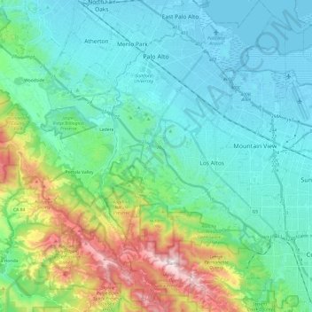
Name: Palo Alto topographic map, elevation, terrain.
Location: Palo Alto, Santa Clara County, California, United States (37.28768 -122.20266 37.47894 -122.07002)
Average elevation: 186 m
Minimum elevation: -5 m
Maximum elevation: 853 m
Thank you for supporting this site ❤️
Make a donation
Make a donation
Other topographic maps
Click on a map to view its topography, its elevation and its terrain.
Sierra Vista Open Space Preserve
United States > California > Santa Clara County > San Jose
Average elevation: 484 m