
Bachtel topographic map
Interactive map
Click on the map to display elevation.
About this map
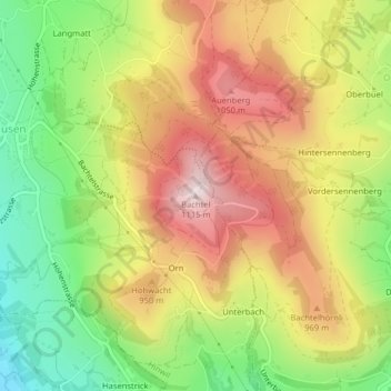
Name: Bachtel topographic map, elevation, terrain.
Location: Bachtel, Hinwil, Bezirk Hinwil, Zürich, 8342, Schweiz (47.29414 8.88568 47.29424 8.88578)
Average elevation: 868 m
Minimum elevation: 622 m
Maximum elevation: 1,112 m
Südöstlich, unterhalb des Gipfels, liegt auf ca. 955 Meter Höhe der Bachtelspalt. Es handelt sich um eine Spalte, die 1939 beim Abrutschen eines NagelfluhKopfes entstand. Sie ist begehbar, aber sehr eng.
Other topographic maps
Click on a map to view its topography, its elevation and its terrain.
Underhus (Wernetshausen)
Schweiz > Zürich > Bezirk Hinwil > Hinwil
Underhus (Wernetshausen), Hinwil, Bezirk Hinwil, Zürich, Schweiz
Average elevation: 783 m