
Rinderweidhoren topographic map
Interactive map
Click on the map to display elevation.
About this map
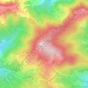
Name: Rinderweidhoren topographic map, elevation, terrain.
Location: Rinderweidhoren, Altendorf, March, Schwyz, 8846, Schweiz (47.13866 8.84499 47.13876 8.84509)
Average elevation: 1,155 m
Minimum elevation: 976 m
Maximum elevation: 1,309 m
Other topographic maps
Click on a map to view its topography, its elevation and its terrain.