
Bristen topographic map
Interactive map
Click on the map to display elevation.
About this map
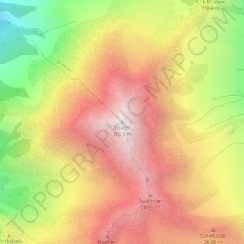
Name: Bristen topographic map, elevation, terrain.
Location: Bristen, Gurtnellen, Uri, 6476, Schweiz (46.73685 8.68128 46.73695 8.68138)
Average elevation: 2,293 m
Minimum elevation: 1,304 m
Maximum elevation: 3,061 m
Other topographic maps
Click on a map to view its topography, its elevation and its terrain.
Bächenstock
Schweiz > Uri > Gurtnellen
Bächenstock, Gurtnellen, Uri, 6484, Schweiz
Average elevation: 2,428 m
Rienzenstock
Schweiz > Uri > Gurtnellen
Rienzenstock, Gurtnellen, Uri, 6484, Schweiz
Average elevation: 2,387 m