
Sintra topographic map
Interactive map
Click on the map to display elevation.
About this map
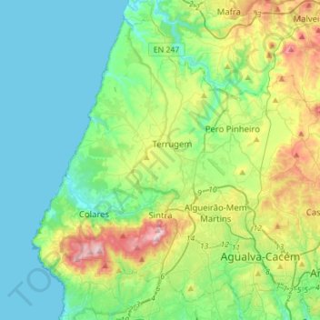
Name: Sintra topographic map, elevation, terrain.
Location: Sintra, Lissabon, Portugal (38.73858 -9.50053 38.93243 -9.22069)
Average elevation: 127 m
Minimum elevation: 0 m
Maximum elevation: 499 m
Other topographic maps
Click on a map to view its topography, its elevation and its terrain.
Aboboreira
Aboboreira, Mafra, Lissabon, 2665-004, Portugal
Average elevation: 86 m
Cezaredas
Portugal > Lissabon > Reguengo Grande
Cezaredas, Reguengo Grande, Lourinhã, Lissabon, 2540-512, Portugal
Average elevation: 131 m
Moledo
Portugal > Lissabon > São Bartolomeu dos Galegos e Moledo > Moledo
Moledo, São Bartolomeu dos Galegos e Moledo, Lourinhã, Lissabon, Portugal
Average elevation: 136 m